Concordia
 The most beautiful place on Earth, Concordia, heart of the Karakoram range in Pakistan. Concordia is home to four of the world’s fourteen ‘Eight-Thousanders’. It is the best place for mountain hikers. The place is considered to be one of the most beautiful places on Earth. The sight provides breathtaking views of a number of notable peaks of Pakistan, such as the Godwin Austin, Gasherburn I, Broad Peak and others.
Muzaffarabad

Muzaffarabad is the capital of Azad Kashmir. The city lies in the North of Pakistan. Apart from the promising sceneries and beautiful valleys, the city is home to two historical forts: the Red Fort (also known as the Chak Fort) and the Black Fort.
People from the South visit Muzaffarabad in summers to escape away from the heat and enjoy the pleasant weather.
Gorakh Hill Station
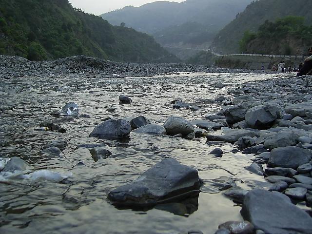
 Gorakh is a hill station situation in the Dadu district in the province of Sindh. Situated at a height of 1,734 meters, is the only hill station in the province of Sindh. This is a hill station which is being developed at the moment. Though visits are possible but there is a need of proper hotels / motels in the area. This is the only place where it snows in winters.
Attabad Lake

Also known as the Hunza Lake, situated in the Hunza Valley was created as a result of the landslides in January 2010. It is one of the biggest artificially created lakes of Pakistan.
Pir Sohawa
 Pir Sohawa is the most visited place in Islamabad. It is located at an elevation of 5000 ft. It is located in a picturesque valley giving an excellent sight of the capital city. The place has a number of restaurants, where visitors can enjoy the food and the view along. This place will provide the visitors a view of the urban city on one side and as they turn their head on the other side, they’ll have a scenic view of the jungles and trees on Margalla hills.
Hingol National Park
 The largest national park in Pakistan, located in the Makran coast in Balochistan. This national park covers part of the three districts of Balochistan namely: Gwadar, Lasbela and Awaran. Balochistan has a number of mud volcanoes and this park has a few of them. This park also covers a large area where the Hingol river
 can be seen and thus this park supports a significant diversity of bird and fish. Hingol National Park is known to support at least 35 species of mammals, 65 species of amphibians and reptiles and 185 species of birds. Some 250 plant species were recorded in the initial surveys including 7 yet undescribed species.
Port Grand
 Port grand is a newly constructed complex that has integrated together food, fun, sightseeing and shopping. This complex is situated in the biggest port city of Pakistan, Karachi. The complex depicts an overall atmosphere of modernism along with serenity. Port grand has been a blessing for the people of city of lights; Karachi. Port grand has been dedicated to building an open eco-friendly environment, with special focus on regeneration.
Khewra Salt Mine
 World’s second largest salt mine, located in Khewra. It is a major tourist attraction with around 250,000 tourists visiting the place every year. There’s a train that takes the visitors inside the mine. Inside the salt mine, there are a number of replicas made with salt bricks of major tourist attractions in Pakistan such as the Badhshahi Mosque, Minar e Pakistan, Mall road of Murree etc.
Hanna Lake

Hanna Lake is an alluring picnic place, situated near the city of Quetta. The lake has a vast variety of eye catching sights. The lake’s water is turquoise in color which gives a good contrast with the mountainous range around. You can take a boat ride or sit in the lake side restaurant and sip chai and enjoy the scenery.
A must visit place if you go to Quetta. This is the one of the biggest and most accessible tourist place in Balochistan.
Mall Road
 Mall road, Murree is a haven for all the shopping maniacs. From jewellery to bags, clothes to shoes, everything is available in a very low price. You’ll find the cheapest stuff here. Good bargainers can bargain upto half of the original price. A must visit place if you have to buy gifts for family and friends.
Ziarat
 Ziarat is the capital of Ziarat district in Balochistan. It is a very good family resort place and offers a number of tourist attractions such as the Juniper forest, Jinnah’s Ziarat residency and a small dam. Ziarat is famous for the variety of fruits mainly cherries and apples. A must visit place in summers as the weather becomes really pleasant.
Karachi beach

Karachi is not only about tall buildings, market places, buzzing traffic horns… The densely populated city Karachi is blessed with a range of beach spots where people can go and enjoy a calm holiday. These places are an oasis of serenity amidst the bustling city.
Although these beaches have been well polluted by the industrial waste but still there are some virgin spots where people can enjoy and have a sense of calm. Some of the well known beach spots in Karachi are: Seaview, Cape Monze, Clifton Beach, French Beach, Gadani, Hawke’s Bay, Manora Island, Paradise Point and Sandspit Beach.
Port Fountain
 Karachi has the third tallest fountain in the world. Situated next to the Oyster Rocks, Karachi harbor, this fountain raises water upto 620 ft.
Ansoo Lake
Ansoo Lake is located in Kaghan Valley of District Mansehra, Khyber Pakhtunkhwa, Pakistan. It is located at an altitude of 13,927 feet (4245 meters) above sea level and considered among one of the highest lakes of Himalayas. The lake is situated near Malika Parbat, the highest mountain of Kaghan Valley

Overview:

According to a resident of Naran Valley, M. Tahir, Ansoo Lake is his discovery and he named this Lake as Ansoo Jheel (transformation in English: “Tear Lake”). The lake (Jheel) is shaped like a tear (Ansoo) that why it is named Ansoo Lake. The lake has become very popular attractions for tourists in a very short time.
It is said that one need to be lucky to behold the beautiful Ansoo Lake. Because sometimes when you reach the lake after hours difficult trekking, the lake does not viewable due to fog or rain. Track to the lake itself present several breathtaking and picturesque views to the visitors. After 5 hours of trek a hill comes, and when you look down to the other side from the summit of the hill, Ansoo Lake is there saying behold I am what brings you here, away from the crowds and communities of human. Traveling a little more will take you closer to the bank of lake. The lake stays covered in snow whole year except from July to August. It is said that best time for this trek is between July 10 to August 15 and one can see the mirroring waters of lake during this period of time.

How to reach:
Aansoo Lake can be reached using two treks;
From Lake Saif-ul-Malook
From Mahandri through Manoor Village
From Lake Saif-ul-Malook:
It takes seven to nine hours of trek for a round trip from Lake Saif-ul-Malook to Ansoo Lake. It is recommended to set off early in the morning. It would be better if you spend night at Lake Saif-ul-Malook and start traveling as early as possible in the morning. This trek can be separated into two halves. The first part is through a valley alongside river to the base camp of Malika Parbat. The second steeper part is from the base camp of Malika Parbat to Ansoo Lake.
From Mahandri through Manoor Village:
 The second trek to set off for Ansoo Lake is a village named Mahandri, located about 40 kilometers (25 miles) to the south of Naran. Turning left from Mahandri Bazar, a jeep track leads to Village Manoor. This valley is great gift for nature lovers and full heart touching picturesque views. You can reach here on jeep but you need to walk from here. After 6-7 hours of trek a lush green meadow called “Dher” comes. From here trek starts to incline. After 3-4 hours of trek from Dher at a height of about 14,000 feet you can see the Ansoo Lake.
Preparations for Trek:
Bring tents and sleeping bags and food with you for in case you need to camps somewhere due to rough weather conditions like snow fall, heavy rain or land slide.
Hire a guide and horses for the trek. (This can be arranged from the Lake Saif-ul-Malook).
Keep enough food and water with you. Better to take sandwiches or burgers for food because you don’t need to take any crockery stuff for them.
Use comfortable shoes, warm clothes and especially keep a rain coat with you for rain and snowfall.
Cautions for trekkers:
Avoid trekking to Ansoo Lake in a bad weather. Wait for a fair day.
Diabetes patients and people with respiratory problems should avoid to trek for the lake
The famous picnic spot is endowed with natural beauty and serene environment. Different species of trees dotting lush slopes of the adjoining hills and the cold waters of springs that flow down to this point makes it a major tourist attraction. Natural springs feed the rivers, which swell as the snow in the hilly ranges of Murree and neighbouring areas begins to melt. This small town, at 15 minutes drive from the garrison city is also known as the gateway to Galyat.
.jpg)
Evenings at this point are every enjoyable, as there is a lot of hustle and bustle. People along with their younger ones can be seen enjoying the cold water. Some are seen splashing it on to their siblings, while others just standing in the river with their feet submerged in the water of the Harnoi River.

Some families, cramped for time, just bring prepared meals from home and enjoy a nice picnic right next to the river. “A more organised way of doing things would certainly help, the way hotels and stall owners are going about their business is quite haphazard,” said Shariq, who was visiting with his family.
The Harnoi picnic point also offers fun activities for the children. The merry-go-rounds and other recreational fixtures are certainly the crowd-pullers among the younger lot. Horse rides for the children and even the youngsters is another enthralling activity one can enjoy here.
 |
| Add caption |
 Yet, the picnickers who prefer to spend time at Harnoi picnic spot before leaving for Nathiagali or Ayubia appear to be dissatisfied with the arrangements. “It is really a very good picnic point but was not developed the way it should be,-district administration must bring about improvements,” said Saad, a visitor from Islamabad.
Another woman picnicker, Naeema Chaudhry from Lahore, said that she had been visiting this point for the last three years, but there had been no developments since then. She also raised objections on the open sale of Shisha smoking at this point.
Hania Malik, another young student, said that the area should be fenced with chairs and benches for the picnickers and developing this point on modern lines could earn the national exchequer a handsome annual income.

She also felt the need of deployment of police security for the woman picnickers who she claimed were vulnerable to harassment.
When approached for comments, an official of Tehsil Municipal Administration Abbottabad said that during the district government system it was developed to some extent despite the fund shortage. “But, with the end of local government system the plan of developing this point was shelved. He however said that the administration was mulling to bring about improvement at this point.
Pakistan Monument + Rawal lake
 The Pakistan Monument in Islamabad, Pakistan, is a national monument representing the nation's four provinces and three territories. After a competition among many renowned architects, Arif Masood’s plan was selected for the final design. The blooming flower shape of the monument represents Pakistan's progress as a rapidly developing country. The four main petals of the monument represent the four provinces (Balochistan, Khyber-Pakhtunkhwa, Punjab, and Sindh), while the three smaller petals represent the three territories (Gilgit-Baltistan, Azad Kashmir and the Federally Administered Tribal Areas). The Monument has been designed to reflect the culture and civilization of the country and depicts the story of the Pakistan Movement, dedicated to those who sacrificed themselves for future generations.
From air the monument looks like a star (center) and a crescent moon (formed by walls forming the petals), these represent the star and crescent on Pakistan's flag.
 Conception[edit source
During the initial stages the plan was envisioned and started by Uxi Mufti son of Mumtaz Mufti in 2005 later the plan to build a national monument in the capital city of Pakistan was undertaken by the Ministry of Culture which was under Hamad Kashif at that time. In this respect, Pakistan Council of Architects and Town Planners (PCATP) organised a national competition around the theme of signifying strength, unity and dedication of the people of Pakistan into an icon representing an independent and free nation.
From a total of twenty submissions, three were short-listed. Finally, the design proposed by Arif Masoud was selected for construction, that revolved around the creation and development of the country.
Structure
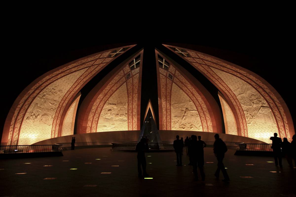
The monument is located at the west viewpoint of the Shakarparian Hills, and is spread over a total area of 2.8 hectares. The high location makes the monument visible from across the twin cities of Islamabad and Rawalpindi. The foundation stone was laid on 25 May 2004 and the complex was completed by the end of 2006 for inauguration on 23 March 2007. The total cost incurred was more than Rs.580 million.
The structure comprises four blossoming flower petals, built of granite, representing the unity of Pakistani people. The inner walls of the petals are decorated with murals. The central platform is made in the shape of a five-pointed star which is surrounded by a water body. A metallic crescent surrounding the star is inscribed with sayings of Muhammad Ali Jinnah and poetry of Allama Iqbal.
Shaheer ul Zaman Khan Goheer ul Zaman Khan Mashood ul Zaman Khan Faheer ul Zaman Khan Taheer ul Zaman Khan
Rawal lake
 From Wikipedia, the free encyclopedia
Rawal lake
Rawal Lake1.JPG
Location Margalla Hills National Park
Type reservoir
Catchment area 106.25 sq mi (275.2 km2)
Basin countries Pakistan
Surface area 8.8 km
Max. depth 102 ft (31 m)
Rawal Lake (Urdu: جھیل راول) in Pakistan is an artificial reservoir that provides the water needs for the cities of Rawalpindi and Islamabad. Korang River along with some other small streams coming from Margalla Hills have been set to form this artificial lake which covers an area of 8.8 km². Korang River is the outlet stream of Rawal Dam. Rawal Lake is located within an isolated section of the Margalla Hills National Park.
The area around the lake has been planted with flowering trees and laid out with gardens, picnic spots, and secluded paths. The terraced garden and the lake are used for picnics, fishing and boating. The highest point in the garden offers a panoramic view of the lake, Margalla and Murree hills, Rawalpindi and Islamabad.
Boating, sailing, water skating and diving facilities are organized by private clubs.
To the west of the lake is the Islamabad Club, which offers different sporting facilities.
Wildlife[edit source
The reservoir is of considerable importance for wintering waterfowl, especially Anas platyrhynchos.
Resident mammals include the common Fox, Pangolin, Porcupine, Jungle cat, Jackal, Wild boar and yellow-throated marten.
Reptiles include Indian Cobra and Russell's Viper.
It is a good place for birds watching, as the majority of Birds of Islamabad are found here.
Fishery[edit source | editbeta]
There are 15 fish species belonging to 11 genera that present in Rawal Lake. The fish species in Rawal lake and its tributaries include: Doula (Channa channa), Rahu (Labeorohita), Thaila (Catla catla), Mori(Cirrhinus mrigala), Carp fish (Cyprinus carpio)and Talapia(Tilapia mossambica).


Features of Rawal LakeLocation: Islamabad Park Area
Longitude: 73° 7' E
Latitude: 33° 41' N
Catchments Area: 106.25 square miles (275 km²)
Features of Rawal Lake dam[edit source | editbeta]
Type of dam: partly arched gravity dam (stone masonry)
Crest level: 1,742 ft (531 m)
Crest length: 700 ft (210 m)
Maximum height: 133.5 ft (40.7 m)
Sun rises at Rawal Dam lake view park
Saddle[edit source | editbeta]
 Length 6,991 ft (2,131 m)
Height 24 ft (7.3 m)
Spillway[edit source | editbeta]
Type: Ogee gated structure
Discharge Capacity: 82000 ft³/s (2,300 m³/s)
Reservoir[edit source | editbeta]
Area: 3 square miles (7.8 km2)
Maximum depth: 102 feet (31 m)
Live storage: 43,000 acre feet (53,000,000 m3)
Dead storage: 4,500 acre feet (5,600,000 m3)
Gross capacity: 47,500 acre feet (58,600,000 m3)
Canals[edit source | editbeta]
Left bank canal: length 5 miles (8.0 km)
Capacity: 40 ft³/s (1.1 m³/s)
Right bank canal: length 1.5 miles (2.4 km)
Capacity: 70 ft³/s (2.0 m³/s)
Drinking water supply[edit source | editbeta]
Rawalpindi: Template:Convert/e6USgal/d
Islamabad: Template:Convert/e6USgal/d
Command area[edit source | editbeta]
Agriculture: 500 acres (2.0 km2)
No comments:
Post a Comment