Bahawalpur (Punjabi, Urdu: بہاولپور), located in Punjab, is the twelfth largest city in Pakistan. In 2007, the city's population was recorded to have risen to 798,509 from 403,408 in 1998. The city is capital of Bahawalpur District. The city was once the capital of the former princely state and later the province of Bahawalpur. The city was home to various Nawabs (rulers) and counted as part of the Rajputana states (now Rajasthan, India). The city is known for its famous palaces such as the Noor Mahal, Sadiq Ghar Palace, and Darbar Mahal, as well as the ancient fort of Derawar in the Cholistan Desert bordering India. The city is located near the historical and ancient cities of Uch and Harappa, which were once a stronghold of the Delhi Sultanate and Indus Valley Civilisation. The city is home to one of the few natural safari parks in Pakistan, Lal Suhanra National Park.
History
Main article: Bahawalpur (princely state)
The city was founded in 1748 by Nawab Mohammad Bahawal Khan Abbasi I. As the family claimed descent from the Abbasid Caliphs the city was also called Baghdad al-jadīd (بغداد الجديد, New Baghdad). The princely state of Bahawalpur was founded in 1802 by Nawab Mohammad Bahawal Khan II after the break-up of the Durrani Empire. The city is over 4.51 kilometres long. Nawab Mohammad Bahawal Khan III signed a treaty with the British on 22 February 1833, guaranteeing the independence of the Nawab. The state acceded to Pakistan on 7 October 1947 when Nawab Sadiq Muhammad Khan Abbasi V Bahadur[3] decided to join Pakistan at the time of independence. The predominantly Muslim population supported Muslim League and Pakistan Movement. After the independence of Pakistan in 1947, the minority Hindus and Sikhs migrated to India while the Muslims refugees from India settled down in the Bahawalpur state. Bahawalpur became a province of Pakistan in 1952 and was merged into the province of West Pakistan on 14 October 1955. When West Pakistan was divided into four provinces – Sindh, Balochistan, Khyber Pakhtunkhwa, and Punjab – Bahawalpur was amalgamated in Punjab.
Geography and climate
The city, which lies just south of the Sutlej River, is the site of the Adamwahan Empress Bridge, the only railway bridge over the Sutlej in Pakistan. It is situated 90 km from Multan, 420 km from Lahore, 122 km from Burewala, 90 km from Vehari, 270 km from Faisalabad and about 700 km from the national capital, Islamabad. The west region of the city is called the Sindh. It is a fertile alluvial tract in the Sutlej River valley that is irrigated by floodwaters, planted with groves of date palm trees, and thickly populated forests. The chief crops are wheat, gram, cotton, sugarcane, and dates. Mango Sheep and cattle are raised for export of wool and hides. East of Bahawalpur is the Pat, or Bar, a tract of land considerably higher than the adjoining valley. It is chiefly desert irrigated by the Sutlej inundation canals and yields crops of wheat, cotton, and sugarcane. Farther east, the Cholistan, is a barren desert tract, bounded on the north and west by the Hakra depression with mound ruins of old settlements along its high banks; it is still inhabited by nomads.[citation needed]
The climate is mainly hot and dry. In the summer the temperature reaches the high forties (Celsius) during the day and the nights are slightly cooler. Since the city is located in a desert environment there is little rainfall. Weather conditions reach extremes in both summer and winter. The average temperature in summer is 33 °C (91 °F) and 18 °C (64 °F) in winter. The average rainfall is 20 to 25 cm annually.[citation needed]
Flora and fauna
The most commonly seen animals in the city include the hog deer, ravine deer, black buck and blue bull. Fox, jackals, hares, wild boars, porcupines, mongoose, arks, owls and hawks are also found in large numbers.
The Bahawalpur Zoo, is located in Bahawalpur. Spread over an area of several acres inside the city, it contains a variety of animal species, including Asiatic lions, Bengal tigers, hyenas, leopards, and peacocks. The zoo has a collection of 130 animals and 700 birds from tropical regions, particularly those found in the Cholistan region. The zoo occasionally breeds and supplies animals to other zoos in the country. It also has an aquarium and zoological museum with stuffed rare birds and animals.
Located 35 kilometres east of the city is the Lal Suhanra National Parkhousing large animals including lions and rhinoceros.
Language
Languages spoken in Bahawalpur include:
Punjabi Language different dialects including Saraiki,[4] Riasti, Standard (Majhi) and Choolistani spoken by majority of the population. Baba Bulleh Shah a legendary poet of Punjabi language was born in Uch near Bahawalpur.
Urdu, the national language, widely understood
English, the official language, is also understood and spoken by the educated elite
Balochi is also spoken by some people.[6]
Economy
Irrigation from canals such as this provides the city with fertile soil for crop production.
The main crops for which Bahawalpur is recognised are cotton, sugarcane, wheat, sunflower seeds, rape/mustard seed and rice. Bahawalpur mangoes, citrus, dates and guavas are some of the fruits exported out of the country. Vegetables include onions, tomatoes, cauliflower, potatoes and carrots. Being an expanding industrial city, the government has revolutionised and libertised various markets, allowing the caustic soda, cotton ginning and pressing, flour mills, fruit juices, general engineering, iron and steel re-rolling mills, looms, oil mills, poultry feed, sugar, textile spinning, textile weaving, vegetable ghee and cooking oil industries to flourish.[7]
Bahawalpur lies at the junction of trade routes from the east, south-east, and south. It is a center for trade in wheat, cotton, millet, and rice grown in the surrounding region. Dates and mangoes are also grown here. Canals supply water for irrigation. The principal industries are cotton ginning, rice and flour milling, and the hand weaving of textiles.
Soap making and cotton ginning are important enterprises; cotton, silk, embroidery, carpets, and extraordinarily delicate pottery are produced. Factories producing cottonseed oil and cottonseed cake were built in the 1970s. It is an important marketing center for the surrounding areas and is located on the crossroads between Peshawar, Lahore, Quetta and Karachi. Bahawalpur is also known for its distinctively embroidered slippers and shoes and filigree pottery.
Bahawalpur has only one railway bridge, the Adamwahan (Empress) Bridge, over the Sutlej River, and also has rail links with Peshawar, the capital of Khyber Pakhtunkhwa and Karachi, the capital of Sindh (which is 899 km from Bahawalpur), making it an important rail centre. The surrounding area is mostly agricultural, which allows agricultural exports to many parts of the world. There is also a large market town for mangoes, dates, wheat, sugarcane, and cotton that brings in continuous demand all year round. It has soap making and cotton spinning factories, as well as enterprises producing silk and cotton textiles, carpets, and pottery. Bahwalpur has sugar mills that provide some of the export market out of the country.
Punjab is Pakistan's most fertile province, rich in both agriculture and ancient history. It is also one of the more stable of the country's regions. The prosperous and hospitable town of Bahawalpur is a gentle introduction to the area, which makes the city an ideal tourist destination. From here one can journey into Cholistan – a sandy wasteland dotted with nomadic communities and windswept forts – or the Lal Suhanra National Park, an important wildlife reserve. Further north is Harappa, which is an important site of the Indus Valley Civilization. Bahawalpur is the most southerly town in the Punjab. There are daily flights from Islamabad about 555 km (344 mi) away. Most of the major destinations in the Punjab can be reached by car, bus, coach, and train.According to PSMA(Pakistan Sugar Mills Association) about 22% of Pakistan's sugar is produced in Bahawalpur division (including Bahawalnagar and Rahim Yar Khan).
Culture
Derawar Fort is on the outskirts of the city in the Cholistan Desert
The city of Bahawalpur has a rich heritage and is an important hot spot for historians as well as archaeologists. Bahawalpur is known for its cotton, silk, embroidery, carpets, and extraordinarily delicate pottery. The Punjab Small Industries Corporation (PSIC) has established a Craft Development Center for Cholistan area, outside Farid Gate, Bahawalpur from where handicrafts manufactured in Cholistan can be purchased. Some of the souvenirs produced in the city include:
Flassi – 4 ft by 7 ft, made of camel hair and cotton yarn; it is used for wall hanging, as a decoration piece and a carpet.
Gindi or Rilli – Made of small pieces of many colours of cotton cloth and needlework; they can be used as wall hangings, bed covers, carpets and blankets.
Changaries – Like big plaques, these are made of palm leaves in different bright colours with beautiful patterns and geometric designs. These are used for keeping the 'chapattis' and also as a wall decoration.
Khalti – Like a purse embroidered on top with multicoloured threads.
Artwork – An attractive type of embroidery done on dupatta, kurta and chaddar, etc.
The main shopping centres of Bahawalpur are Shahi Bazaar, Machli Bazaar, Farid Gate and the Mall. The commercial area in Satellite Town is a newly developed center that is gaining popularity. A few shopping malls, including Bobby Plaza, Takbeer Shopping Mall, Time, and Prince, cater for all kinds of needs. Shopping is a major attraction in the city; the city is bustling with traders and craftsmen selling all sorts of artwork for travellers and tourists.
East of Bahawalpur is the Cholistan Desert, which covers an area of about 15,000 km2 and extends into the Thar Desert of India. The region was once watered by the Hakra River, known as the Saravati in vedic times. At one time there were 400 forts in the area and archaeological finds around the Derawar Fort, the only place with a perennial waterhole, indicate that it was contemporaneous with the Indus Valley Civilisation. The average annual rainfall is only 12 cm, and the area's scant cultivation is made possible by underground wells, drawn up by camels. The water is stored in troughs, built by the tribes, between sandhills and din waterholes called tobas. The people are racially similar to those in Rajasthan – tall, with sharp features. They live in large, round, mud and grass huts, usually built on the top of sandhills. On the whole, they are pastoral and nomadic. The main tribes are the Chachar, Mehr, Lar, Paryar, Channar, Chandani and Bohar. The forts here were built at 29 km intervals, which probably served as guard posts for the camel caravan routes. There were three rows of these forts. The first line of forts began from Phulra and ended in Lera, the second from Rukhanpur to Islamgarh, and the third from Bilcaner to Kapoo. Built with double walls of gypsum blocks and mud, they are all in ruins now. Some of them date back to 1000 BC, and were destroyed and rebuilt many times.
Even with all the markets and forts, one thing for which Bahawalpur is recognised above all others is the numerous palaces that still remain intact ever since the fall of the Nawabs. There are countless palaces in the city, locally known as Mahals. Some of the most famous include: Noor Mahal, Gulzar Mahal, Darbar Mahal, Shimla Khoti Sadiq Ghar Palace and Darbar Mahal. The city also has a city gate called Farid Gate, which in its heyday provided the only entrance to the city for its rulers. The gate still remains and is now located in a busy market in the inner city. The Bahawalpur Museum and Bahawalpur National Library house various collections of coins, medals, postage stamps of the former state of Bahawalpur, manuscripts, documents, inscriptions, wood carvings, camel skin paintings, historical models and stone carvings from Islamic and pre-Islamic eras. There is a complete set of medals of all classes issued by the ex-state to its military officers, civilians, and other important citizens of the ex-state.
.jpg)
The city also has several mausoleums of prominent leaders who fought and defended the region over several thousands of years. Some of the most prolific include the tombs of Channen Peer Tomb Yazman and Mausoleums of Haugha Sahib. There is also an old fort of Munde Shahid, 50 km from Bahawalpur and Marot Fort, which are considered to be antiquities. A place outside the Marot Fort is known as 'Baithak Maula Ali'. The tomb of Naugaza is located in the Munde Sharif Fort.
Education
Quaid-e-Azam Medical College, Bahawalpur designed by A. R. Hye
The city boasts a number of reputable educational establishments, most notably The Islamia University of Bahawalpur, Quaid-e-Azam Medical College,Sadiq Girls Women University and Sadiq Public School, which is one of the largest boarding schools in Pakistan. Other top schools include Alpina School, Beaconhouse School Bahawalpur,The Central Public High School, The Moon system of education, The City School, Bloomfield Hall Schools, Askari Kids College,Aims system of education, Umm Al-Qura Education System, Progressive Schooling System, Dar e arqam School, Jinnah Public School, Rangers Public School and College, The Climber Public School, Army Public School, Salsaal Public School, and Dominican Convent School. Notable universities and colleges include: Government Sadiq Egertin College, Post Graduate College,Punjab College Bahawalpur, Arrshhouse College, Government Degree College, Government Sadiq Degree College for Girls, The Islamia University of Bahawalpur, Government College of Technology,The Best college Bahawalpur,Government Sadiq College of Commerce, Government Polytechnic Institute, Government Polytechnic Institute For Women, Government Technical Training Institute,Government Technical High School Bahawalpur, Allama Iqbal College of Commerce, Institute of Science and Information Technology and Government Para Medical School.
Transport
Bahawalpur is well connected with various cities in Pakistan. The city has its own airport built by the Dubai Civil Aviation Department and the CAA. Bahawalpur Airport links the city with various Pakistani cities such as Dera Ghazi Khan, Islamabad, Karachi and Lahore with the national flag carrier, Pakistan International Airlines. The airline has launched international flights to Dubai, and plans to introduce more international destinations. There are daily train and bus services from Multan, Lahore, Sukkur and Karachi to Bahawalpur.taxicabs and rickshaws are plentiful in the city. Cars are also available for hire in the city.
Sport
Bahawalpur is home to Bahawalpur Stags, the team which participates in the Twenty 20 and List A cricket tournaments. The inaugural Quaid-i-Azam Trophy in 1953-54 was won by the Bahawalpur cricket team. Bahawal Stadium is the home ground of the team. It hosted a Test match between India and Pakistan in 1954-55, India's inaugural tour of Paksitan. It was the first cricket ground in Western Pakistan to host a Test match.
Suhanra National Park, an important wildlife reserve. Further north is Harappa which is, after Moenjodaro, the second most important site of the Indus Valley civilisation. Bahawalpur is the most southerly town in the Punjab. There are dialy flights from Islamabad about 555km (344mi) away. Most of the major destinations in the Punjab can be reached by bus, mini bus, and train.
Bahawalpur Bahawalpur is 899 km from Karachi. The founder of the state of Bahawalpur was Nawab Bahawal Khan Abbasi I. The Abbasi family ruled over the State for more than 200 years (1748 to 1954). during the rule of the last Nawab Sir Sadiq Muhammad Khan Abbasi V, Bahawalpur State was merged with Pakistan in 1954. Bahawalpur was formerly the capital of the state and now is the District and Divisional Headquarters of Bahawalpur Division. It is an important marketing centre for the surrounding areas and is located on the cross roads between Peshawar, Lahore, Quetta and Karachi. Saraiki is the local language of the area. Urdu, Punjabi and English are also spoken and understood by most the people. There are three palaces, the main one Noor Mehal. Bahawalpur is also known for its distinctly embroiderd slippers and shoes and the filigree pottery which is made here. It has a marble mosque in the Fawara Chowk and a few British buildings like the Science College. Bahawalpur has a modest museum having a fine collection of coins, medals, postage stamps of former State of Bahawalpur, manuscripts, documents, inscriptions, wood carvings, camel skin paintings, historical models and stone carving etc. of Islamic and pre-Islamic period. The Cholistan desert zone and the cultural life of this area, forts, monuments, palaces, museum, zoo, stadium and a fine cricket ground in and around Bahawalpur are main attractions. Lal Suhanra National Park The Lal Suhanra National Park is ideal for recreation, education or research but shooting is forbidden. This park, 36 kms to the east of Bahawalpur, is a combination of a natural lake and a beautiful forest on 77480 acres of land on both sides of the Bahawal canal having watchtowers, catching ground, tourist huts, rest-houses, camping grounds and treks for the visitors and lovers of adventure. Hog deer, ravine deer, black buck and nilgai are common. Fox, jackals, hares, porcupines, mongoose, larks, owls and hawks are also found. Wild boars are in large number in the forest areas. Lal Suhanra National Park which is actually a wildlife sancturary worth a visit.
The Cholistan Desert
East of Bahawalpur is the Cholistan Desert which covers an area of about 15,000 square km and extends into the Thar Desert of India. The region was once watered by the Hakra River, known as the Saravati in vedic times. At one time there were 400 forts in the area and archaeological finds around the Darawar Fort, the only place with a perennial waterhole, indicate that it was contemporaneous with the Indus Valley Civilisation. The average annual rainfall is only 12 cm, and the little cultivation there is, is made possible by underground wells, drawn up by the camels. The water is stored in troughs, built by the tribes, between sandhills and din waterholes called tobas. The people are racially similar to those in Rajasthan - tall, with sharp features. They live in large, round, mud and grass huts, usually built on the top of sandhills. On the whole, they are pastoral and nomadic. The main tribes are the Chachar, Mehr, Lar, Paryar, Channar, Chandani and Bohar. The forts here were built at 29 km intervals, which probably served as guard posts for the camel caravan routes. There were three rows of these forts. the first line of forts began from Phulra and ended in Lera, the second from Rukhanpur to Islamgarh, and the third from Bilcaner to Kapoo. They are all in ruins now, and you can see that they were built with double walls of gypsum blocks and mud. Some of them date back to 1000 BC, and were destroyed and rebuilt many times.
Desert Jeep Rally.
The most interesting event held annually the month ot March is the Cholistan's Desert Jeep Rally. it is held at famous Derawar Fort and vehicles covers the round about distance of 250 km. It includes the vehicles ranging from 1300 cc to 3000 cc plus. Thrillers gathers from all over the Pakistan to enjoy the spring in sand.
A city of good summer/winter sunshine. A lovely place to visit in winters. An international level and free sports facility and library. A safari park and loads of rustic life on show.
This city also offers a Zoo which is one of its kind. it has a big population of lions, including Bengal tigers.
Bahawalpur is small and its easy to find your way around the town. Its a nice place to spend a few days if you are tired from being in big cities like Lahore and Multan, or tired of being in the middle of nowhere in Cholistan. The central bazar still feels quite historical, although a bit ramshackle. The Cantt area is nice and relatively green.
Bahawalpur City, is located in southeastern Punjab province, Pakistan. Bahawalpur is 889 kms from Karachi.
Saraiki is the local language of the area. Urdu, Punjabi and English are also spoken and understood by most of the people.
Bahawalpur originally was a vassal of the great Sikh empire built by Maharajah Ranjeet Singh. In 1936 Bahawalpur stopped paying tribute and openly declared independence. In the Anglo Sikh wars Bahawalpur supported the British and this gurantedd its survival.The founder of the
State of Bahawalpur was Nawab Bahawal Khan Abbasi I. The Abbasi family ruled over the State for more than 200 years (1748 to 1954). During the rule of the last Nawab Sir Sadiq Muhammad Khan Abbasi V, Bahawalpur State was merged with Pakistan. During the 1960's (1954) the Nawab agreed (Agreement Dated 3rd October, 1947) for Bahawalpur to be absorbed into modern Pakistan. He was however given special priveledges including the right to import several cars duty free each year. Bahawalpur was formerly the capital of the state and now is the District and Divisional Headquarters of Bahawalpur Division.
The Nawabs of Bahawalpur originally came from Sindh; they formed a princely state and assumed independence in 1802.
The City, which lies just south of the Sutlej River, was founded in 1748 by Muhammad Bahawal Khan and was incorporated as a municipality in 1874. It is the site of the Adamwahan (Empress) Bridge, the only Railway Bridge over the Sutlej River in Pakistan, and has rail links with Peshawar and Karachi.
The region surrounding Bahawalpur to the west, called the Sindh, is a fertile alluvial tract in the Sutlej River valley that is irrigated by floodwaters, planted with groves of date palms, and thickly populated. The chief crops are wheat, gram, cotton, sugarcane, and dates. Sheep and cattle are raised for export of wool and hides. East of Bahawalpur is the Pat, or Bar, a tract of land considerably higher than the adjoining valley. It is chiefly desert irrigated by the Sutlej inundation canals and yields crops of wheat, cotton, and sugarcane. Farther east, the Rohi, or Cholistan, is a barren desert tract, bounded on the north and west by the Hakra depression with mound ruins of old settlements along its high banks; it is still inhabited by nomads. The principal inhabitants of the region surrounding Bahawalpur are Jat and Baluchi peoples. There are many historical sites in the area, including Uch, southwest of Bahawalpur, an ancient town dating from Indo-Scythian (Yüeh-chih) settlement (c. 128 BC to AD 450). Pop. (1981) City, 180,263; (1981 prelim.) metropolitan area, 695,000.
Bahawalpur is also an important agricultural training and educational center. Soapmaking and cotton ginning are important enterprises; cotton, silk, embroidery, carpets, and extraordinarily delicate pottery are produced. Factories producing cottonseed oil and cottonseed cake were built in the 1970s. It is an important marketing center for the surrounding areas and is located on the crossroads between Peshawar, Lahore, Quetta and Karachi. Bahawalpur is also known for its distinctly embroidered slippers and shoes and the filigree pottery which is made here.
The City is located favorably for commerce, lying at the junction of trade routes from the east, south-east, and south. It is a center for trade in wheat, cotton, millet, and rice grown in the surrounding region. Dates and mangoes are also grown here. Canals supply water for irrigation. The principal industries are cotton ginning, rice and flour milling, and the handweaving of textiles.
Sutlej (Chinese, Langqên Zangbo or Xiangquan He; Indian, Satlej), chief tributary of the Indus River. It rises in Tibet, flows south-west through Himachal Pradesh State, India, and then passes through the great arid plains of Punjab Province, Pakistan, joining the Indus after a course of about 1,450 km (900 mi.). The Sutlej is the south-easternmost of the five rivers of the Punjab, the other four being its two main tributaries, the Beâs and the Chenab, together with two branches of the latter. Below the confluence of the Beâs, the river is sometimes called the Ghara, and its lowest course, after receiving the Chenab, is called the Panjnad ("five rivers").
Rulers of Bahawalpur
The rulers were sindhi abbasids of shikarpur and sukkur who captured thses areas.Because of this fact,people of upper sindh which afterwords became state bahawalpur did not dislike the rulers.They took the title of Amir until 1740, when the title changed to Nawab Amir. Although the title was abolished in 1955, the current head of the House of Bahawalpur ( Sallah ud-din Muhammad Khan) uses the title informally. From 1942, the Nawabs were assisted by Prime Ministers.

ABBAS NAGAR
Abbas Nagar is an important QASBA(Village) of Bahawalpur district. It is located on Bahawalpur, Bahawal Nagar road at 25KM from Bahawalpur. main crops of Abbas Nagar are Cotton,Wheat and Sugar Cane.The population of the QASBA is 15000 (Appro as per Govt. in 2004).
Tenure Nawab Amir of Bahawalpur 1690 - 1702 Bahadur Khan II 1702 - 1723 Mobarak Khan I 1723 - 11 April 1746 Sadeq Mohammad Khan I 11 April 1746 - 12 June 1750 Mohammad Bahawal Khan I 12 June 1750 - 4 June 1772 Mobarak Khan II 4 June 1772 - 13 August 1809 Mohammad Bahawal Khan II 13 August 1809 - 17 April 1826 Sadeq Mohammad Khan II 17 April 1826 - 19 October 1852 Mohammad Bahawal Khan III 19 October 1852 - 20 February 1853 Sadeq Mohammad Khan III 20 February 1853 - 3 October 1858 Fath Mohammad Khan 3 October 1858 - 25 March 1866 Mohammad Bahawal Khan IV 25 March 1866 - 14 February 1899 Sadeq Mohammad Khan IV 14 February 1899 - 15 February 1907 Mohammad Bahawal Khan V 15 February 1907 - 14 October 1955 Sadeq Mohammad Khan V 14 October 1955 State of Bahawalpur abolished Tenure
Prime Minister of Bahawalpur 1942 - 1947 Sir Richard Marsh Crofton 1948 - 1952 John Dring 1952 - 14 October 1955 A.R. Khan 14 October 1955 State of Bahawalpur abolished
WORTH SITE IN BAHAWAL PUR
Cholistan

Farther east, the Rohi, or Cholistan, is a barren desert tract, bounded on the north and west by the Hakra depression with ruins of old settlements along its high banks; it is still inhabited by nomads. It is at a distance of 30 km. from Bahawalpur. The word 'Cholistan' is derived from the word 'cholna' which means moving.
It covers an area of about 16,000 square km and extends into the Thar Desert of India. The region was once watered by the Hakra River, known as the Saravati in vedic times.
At one time there were 400 forts in the area and archaeological finds around the Darawar Fort, the only place with a perennial waterhole.
The average annual rainfall is only 12 cm, and the little cultivation is made possible by underground wells, drawn up by the camels. The water is stored in troughs, built by the tribes, between sandhills and din waterholes called tobas.
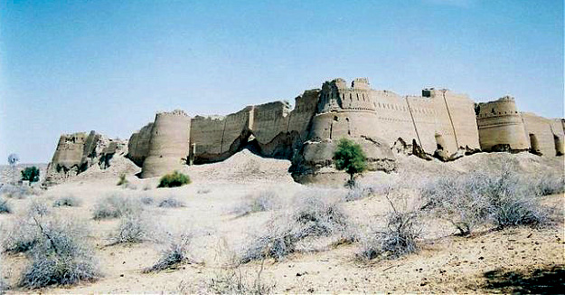
The forts here were built at 29 km intervals, which probably served as guard posts for the camel caravan routes. There were three rows of these forts. the first line of forts began from Phulra and ended in Lera, the second from Rukhanpur to Islamgarh, and the third from Bilcaner to Kapoo. They are all in ruins now, and you can see that they were built with double walls of gypsum blocks and mud. Some of them date back to 1000 BC, and were destroyed and rebuilt many times. Cholistan also boasts of many old forts such as Derawar,Vingrot, Banwar, Marcot, Wilhar, Maujgharh, Mao, Phuira and Din-gharh etc.
We talk about going abroad all the time, forgetting that there is so much to explore in our own country. And if we talk about roaming in Pakistan, only the north seems like an option. But in the marginalized south of Punjab, there lies a city whose history goes back to 1802 and can offer so many places to visit that it can amaze one who hasn't been there. Let's explore the amazing Bahawalpur and one small tip: before summer comes and the city heats up, make a plan because you won't regret it.
Darawar Fort
Utterly Beautiful and amazing, this fort is not to be missed. The Fort was built by Deoraj, a prince of Jaisalmir. It was in possession of royal family of Jaisalmir when it was captured by Abbasis in 1735. As per Bahawalpur Gazetteer (1904), in 1747 the Fort slipped from the hands of Abbasis in the reign of Nawab Bahawal Khan due to his pre-occupations at Shikarpur. Nawab Mubarak Khan took the stronghold back in 1804.

The lofty and rolling battlements made of thin red bricks, ten on each side of the fort are visible from miles around. The circumference wall is about 40 meters high. There are two old vintage guns mounted on pedestals in the dusty courtyard of the Fort. On the western side are small underground cells now infested with bats and wood being eaten by termite. As per the fable the secret to change metal into gold was told to Prince Deoraj, it is believed that there is treasure hidden somewhere. Go and explore it.
Darbar Mahal
If you want to have mughal feeling, go to Darbar Mehal. The mehal itself is under the control of Pakistan Army, but its grounds are a popular tourist attraction since they provide proximity and excellent view of the architecture that resembles that of the ancient Mughalai Forts, and is on par with the typical fusion of East Indian and Arabic architectural techniques that were prevalent in the subcontinent during the 1800s. Darbar Mahal was commissioned by Nawab Bahal Khan (V) in 1904, and was one of its kind among other forts that had been built around that time. Originally conceived as the “Bhawal Gerh”; the fort was completed in 1905 and was dedicated to one of the wives of the Nawab. The least you can do it is take your wife to visit and dedicate the trip to her. We hope it works.
 Noor Mahal
When in the evening the lights get on, life gets on at Noor mahal. It is a two story palace with exquisite furniture and tremendous fixtures like cupboards and chandeliers. It is rich with a beautiful collection of arms and a few of the muskets and swords displayed on walls. A beautiful mosque exactly like the Aitchison College was also added to it. In 1999 this palace was used as an army club and is still in the army’s possession. It is a hotel, a park and a museum attracting millions of visitors each year. School, colleges and university trips are arranged to this historical palace every year. If you haven't spent an evening in its lawn sipping mint Margarita and looking at this marvel, you are missing some real thing.
 The Tomb of Bibi jawindi in Uch Sharif
The most elegant building and the prime attraction in Uch is the tomb of Bibi Jind Waddi. Her name has been described by Bibi Jalwandi and Bibi Jind Waddi as well. Since Jind Waddi is a popular name in this region so we believe, this name would be the most appropriate.
It is described by the historians that her mausoleum was built in 1494. The basic structure of her tomb is built by bricks, embellished with stunning glazed tile mosaic. The building is erected in three octagonal stories with lower storey supported by rounded and sloping corner turrets. The second storey was supported with a narrow gallery for walking round and the third is a hemispherical dome, which crowns the building. There is an aesthetically carved wooden mehrab in the West wall. Basically it follows the typical pattern of Multani architecture on which the tombs of Hazrat Rukn-e-Alam and Baha-ud-Deen Zakria are built.
The outside walls of the tomb are completely covered by glazed blue colored tiles while the turrets are surmounted with a bunch of broad flowering leaves. This unique design makes it different from Multani tombs.
Uch Sharif, 75 km from Bahawalpur is a very old town. It is believed that it came into existence way back in 500

BC. Some historians believe that Uch was there even before the advent of Bikramajit when Jains and Buddhist ruled
over the sub-continent. At the time of the invasion by Alexander the Great, Uch was under Hindu rule.
The surviving shrines, sanctuaries, cemeteries, and mausoleums, including the Bibi Jawandi tomb, incorporate
glazed tile and brick revetments, lime plaster panels, terra-cotta embellishments, brick structural walls laid in
earth mortars, and ingenious corner tower buttresses. The famous shrines existing at Uch include those of Hazrat
Bahawal Haleem, Hazrat Jalaluddin Surkh Bukhari, Makhdoom Jahanian Jahangasht, Shaikh Saifuddin Ghazrooni and Bibi
Jawanadi. The shrine of Bibi Jawandi is a Central Asian design, titled in the blue and white faience.
Uch is a small town today and divided into three different quarters known as:
(i) Uch Bukhari, after Hazrat Syed Jalaluddin Bukhari Surkhposh
(ii) Uch Jilani, after the name of Hazrat Shaikh Mohammad Ghaus Qadri Jilani (Bandagi), who came from Halab in 887
AH
(iii) Uch Mughlan after the Mughal rulers.
Sadiq Garh Palace
The only Palace which is far more superior to all others in terms of elegance and glory is named Sadiq Garh Palace. This Palace was established in 1882 by His Highness Nawab Sadiq Muhammad Khan (IV). This Palace was constructed under the supervision of expert engineers with a cost of fifteen lac rupees. The work of construction continued for almost ten years. After the completion of the palace it was inaugurated in the presence of a majestic court.
There is huge wall all around the palace and there are lush green lawns inside it with beautiful plants having colorful flowers. This sky building is a masterpiece of beauty. There is a bastion in every corner of the palace. There is a beautiful dome in the center of the building which looks more beautiful at night when it is glowing with lights of different colors.
 Lal Sohanra National Park
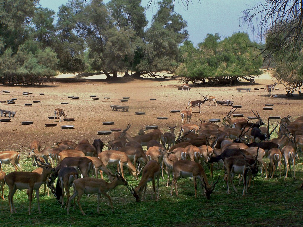
Even the library in Bahwalpur is an architectural marvel. The trip to Lal Suhanra National Park is very interesting for the naturalists. The park was developed in 1972 and is the home of many animals and birds, including the rare Chinkara Gazelle and plentiful wild boar.There is a project here for re-introducing the black buck into their former desert habitat; you can see about 30 of them in the fenced enclosure just inside the forest plantation. In winter there are abundant ducks in the lake. Lal Suhanra is approximately 36 km (22 miles) north-east of Bahawlpur; leave the town by the Khairpur road and fork right after about 30 km (20 miles) on a dirt track to join the desert feeder canal. You can hire a local guide to explore the park. There is a rest house which you can book through the Park Office, 3-A Trust colony, Bahawalpur or you can camp. The imposing architecture of Italian variety lends the building old world charm. The red-brick structure is, in fact, an edifice of Bahawalpur’s identity – a relic of its glorious culture. A small wonder, then, the well-stocked Central Library is counted among the most emblematic of the city’s monuments. The second largest library of Punjab, the Central Library is famous for its treasury of books. Aside from tomes on a whole array of subjects and thousands of documents, including rare manuscripts, of historical importance, it contains antiques such as parts of the Quran said to be scripted by Hazrat Imam Hussain (RA) about 1,400 years ago on a deer hide.Long considered by bibliophiles as one of the prides of Bahawalpur, the library is now struggling for its upkeep, chiefly because funds have tapered off to a trickle. Go there and add have some knowledge while travelling.
 Channan Pir
From Bahawalpur at a distance of 1 hour drive is Channan Pir in Cholistan desert. Channan Pir is a shrine of a Muslim saint, which lies in the desert between Derawar and Din Gargh Forts.
 Burial Ground
Another interesting place worth visiting here is the Nawab Family burial ground where many of the old Nawabs and their families are buried. The tomb here is attractive, built with marble and decorated with blue glazed style.
 Mosque at Bhong
Bhong Mosque is in the Rahim Yar Khan district and is about 200 km from Bahawalpur. This mosque was built by Rais Ghazi, a local landlord of Bhong. Gold leaves have been used for the intricate decorative work in the mosque which has made it famous. It is a site worth visiting for its beauty and the stylish calligraphic work.
 Dera Nawab Sahib
The palaces of the Amirs are located mainly in Dera Nawab Saheb at a distance of 22 miles from Bahawalpur; while, Derawar was the ancestral seat of the rulers of Bahawalpur. It is the gateway to Cholistan, which comprises 1,000 square miles.
 Panjnad Head Works
Panjnad is located 12 km. away from Uch Sharif where all the five rivers of Punjab meet. It is a nice picnic spot with scenic beauty.
 Forts
Forts
The old fort of Munde Shahid, 50 km. from Bahawalpur and Marot Fort are considered to be antiquities. A place outside the

Marot Fort is known as 'Baithuk Maula Ali'. The tomb of 'Naugaza' is located in the Munde Shahid Fort.
Islam Garh Fort
Islam Garh ,the old Bhinwar Fort, was built by Rawal Bhim Singh in Samabat in 1665, as the following inscription on its gate in Babri character proves "Samabat 1665 Asuj Wadi 2, Maharaj Rawal Siri Bhim Singh ji Maharaj". The Fort is situated in the Cholistan area of Tehsil Khanpur. It is 46 kilometers south east of Baghla Fort. The fort is in a dilapidated state.
 Mau Bubarik Fort
According to Tarikh-e-Murad, a fort was built by Raj Hans Karar in Mau Mubarik as a residence for his mother, hence the name Mau refers to mother in local language. The fort was taken by Shah Arghun in 1525 A.D. It was one of the six fortresses of Raj Sahasi 11. It had 20 bastions and Towers. The ramparts were about 549 meters in circumference and the walls very strongly and thickly built. Here the shrine of a saint Sheikh Hakim is of great importance.
 Some Shrines
Other shrines of Bahawalpur region are that of
» Khawaja Noor Muhammad known as Qibla-e-Alam at Chistian
Bahawalpur is circumvented by many pulchritudinous tourist spots, like Lal Sohanra National Park, and famous
 Mosque at Bhong
200 km from Bahawalpur
This mosque was built by Rais Ghazzi, the local landlord of Bhong. Gold leaves have been used for the intricate decorative work and stylish calligraphy in the mosque.
Pattan Minara
8 km east of Rahimyar Khan
This is an extensive site of ruins. There is a tower in the center of four similar smaller towers in this place that are believed top form a Buddhist monastery.
Bhutta Wahan
15 km from Rahim Yar Khan
It is believed to be the birthplace of Sassi, one of the legendary lovers sassi punno. It is also the birth place of one of the sons of the famous courtesans of Akbar the Great. It is a legend that if a child gives birth to a child at this place the child is sure to get the fame of a statesman.
Central Library
The library was built in 1924. It has a vast collection of books and rare manuscripts. It is one of the best libraries in Pakistan.
Bahawalpur Museum
This is a modest museum with a good collection of old coins medals postage stamps, manuscripts inscriptions woodcarvings camel silk paintings historical models stone carvings of the Islamic and Pre-Islamic period.
Zoological Garden
The Bahawalpur zoo is considered to be one of the best in the country. Spread over an area of 25 acres, it has an interesting collection of 120 animals and 750 tropical birds. The zoo has the distinction of breeding lions. It also has an aquarium and museum with stuffed rare birds and animals.
Dring Stadium
Bahawalpur has one of the finest stadiums in the country. It has 5 cricket grounds 2 football stadiums, 1-basketball court 6 lawn tennis courts and a covered swimming pool. It also has one of the best hockey stadiums in the country.
Shrine of Muluk Shah
He was a popular saint. An annual fair is also held here annually.
Jamia Masjid Al-Sadiq
It was made by Nawab Sadiq Khan Abbasi . It has a capacity of 50 to 60 thousand people. It is one of the most beautiful and prominent mosques in Pakistan.
Main Shopping Areas
Shahi Bazar
Machli Bazar
The Mall
Chenone
We hope the history of these seven awesome places will make you visit the city if you have not yet.


 Chiniot suffered much from the Durrani inroads during the last half of the eighteenth century and also during the troubles of I848because it remained the scene of constant fierce struggle among the leaders of local factions. As per the local legend, portion of the wall, surviving in situ, had been built during Hellenic period. The veracity of the wall’s association with Alexander the great is yet to be proven though. But the sit does give evidence of its distant
  During the Mughal era, Chiniot produced many intelligent personalities and talented artisans who occupied positions in the Mughal courts, Nawab Saad Ullah Khan and Nawab Wazir Khan held the post ofPrime Minister of India and the Governor of Lahorerespectively during the rule of King Shah Jehan.
 What this internationally acclaimed craft of the town needs is an institutional patronization and extensive efforts for international marketing? Made in Chiniotfurniture is already being shipped to different countries but so far there are very little marketing efforts being made for this purpose. It can be a potent source of earning foreign exchange if attention is paid to and earnest efforts are made. Sadly, the trained incompetents responsible for export promotion do not see this and the unique potentials are not being taped yet. The first exhibition of Chinioti furniture in Islamabad last year was attended by large number of people from all walks of life. Particularly foreigners appreciated the furniture for its style, solidity and the cost.
 Apart from furniture, there are more attractions for any visitor to this off the beaten track tranquil town. A towering architectural masterpieceShahi Mosque, which was built during rule of Mughal King Shah Jehan by Nawab Saad Ullah Khan in 1655, is still functional. It resembles the Shahi Mosque Delhi that was also built under the supervision of Nawab Saad Ullah Khan. After the invasions of British, the city lost its old glory and importance. However, the historical buildings and their ruins are scattered in and around the city, reflect its wonderful past.
 Another such building is theUmar Hayat Palace commonly known as the Gulzar Mahal. Attracting local and foreign tourist, it is known for its beauty and legendary tales attached to it. The palace is said to have been built by Sheikh Umar Hayat, a rich merchant whose family originally migrated to Chiniot from India.
 Legend has it that in a village fair atPanda Haitian, Umar Hayat fell in love with a performer girl and married. She bore him a son and a daughter.Umar Hayat grew particularly fond of his son whom he named Gulzar - a rose garden or a sign of happiness. It was for his son that Umar Hayat decided to construct a wonderful palace and name after him. Umar Hayat could not see the palace completed and later his sonGulzar died mysteriously in the palace in the early hours of his marriage night.
 The result of the challenge was the creation of Gulzar Manzil. The construction of the palace started in 1923 and Umar Hayat lavishly spent his wealth. According to one account, the supervision of the construction was assigned to Syed Hassan Shah who gathered famous artisans and carried out day and night work for ten years. Elahi Baksh and Rahim Baksh did the wood carving, for which the palace is known. Both were masters of the art. The Punjab District Gazetteers reads:
 Chiniot, a market town in the expanses of Punjab bears a prosperous look. Chiniot has every thing necessary for development – hard working and talented people, fertile land, water, communication infrastructure and clean healthy environment. The furniture industry can be converted into important source of earning though efficient ‘marketing mix’. Given chance Chiniot can be a nice and rich little city of the future.


